![]()
Tamagawa, Yamagata Prefecture
Class IV
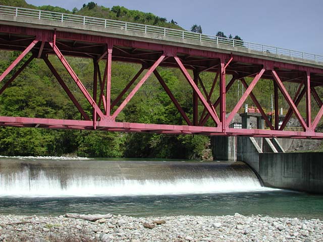
Logistics: Mapple 43 C2. Highway 113 cuts east to west through Yamagata Prefecture. Turn off on to Highway 15 where it heads up along the Tamagawa at the confluence with the Arakawa (west end of this road). There are two sections on the Tamagawa. The top section is 2 km and the lower section is 15 km. The take-out for the lower section is at the Arakawa confluence on river left (hike up at the train bridge). In a couple kilometers Highway 15 turns off across a bridge while the river left road continues as Highway 260. As you continue up the shuttle road you can see the river in a few spots. Approximately 13 km up this road you'll cross the river at a hazardous lowhead dam (photo). The put-in for the lower section is downstream river right of this bridge. To find the take-out for the upper section you will need to continue to a safe spot above the low head dam (there are some good spots about 1 km upstream along river right). It's a little more than a kilometer up the road from the take-out to a road that turns to the right and crosses the Tamagawa. Take this road which heads a short distance up river left. The most challenging drop on this section can be seen from this bridge. Continue to the end of the paved road and hike your boats from the inn following the track through the fields to the river. Area Map.
Season: Best in spring with some good snowmelt or after rains. Unregulated flows make it harder to catch than the majority of Japan's rivers which are dam controlled.
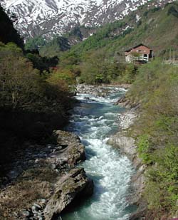
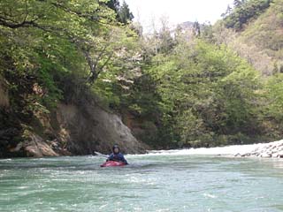
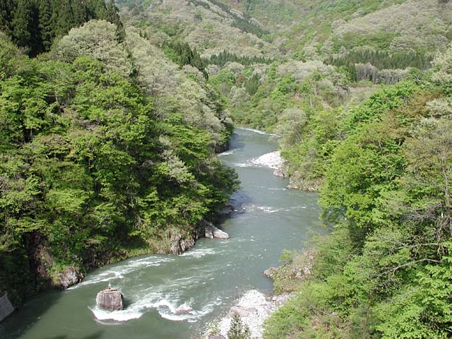
Description: The Tamagawa is a beatiful mountain river in a traditional Japanese rural setting with rice fields and lush forests that bloom with beautiful native flowers in spring. Although present, you will see limited evidence of human influence when you're down in this very scenic river (photo). The river can be hard to catch as rains or heavy snow melt can push flows up significantly and most of the rest of the time the river is too low to run. A great feature of this run is the hot spring bath at the inn that overlooks the upper section.
 Top Section (Kawairiso Inn to Low Head Dam, 2 km, IV+)
This short section has 3 major drops on it. The first starts off right away at the put-in where the river takes a hard bend to the right. A hole forms most of the way across the river, but you can skirt by on river left. After a short recovery pool, the river spreads out across a rock garden rapid and you'll likely have spectators from the bathhouse that overlooks the river. The next big rapid starts just upstream from a footbridge (you can scout it out before your run). The river squeezes through a narrow bedrock canyon with exploding waves along the right (video clip, 3.5 MB). The river then makes a hard bend to the right where a short recovery pool provides a good eddy as you leave the canyon and pass to either side of a large boulder (video clip, 5.2 MB). The most challenging drop on the run (pushing class V at high water) waits just downstream so you can get out here to scout or portage. The river falls several meters over a distance of approximately 200 meters in a maelstrom of big hydraulics before slamming into a large mid-stream boulder (video clip, 6.5 MB). Although the route looks good on river left when scouting from upstream, the easier line is to the right. After a short recovery pool below the bridge the rapids start up again with more continous rock gardens and a somewhat braided channel down to the arch bridge and the takeout.
 Lower Section (Low Head Dam to Arakawa confluence, 15 km, III/IV)
The first section (6 km) is from the bridge at the low head dam to the bridge at the powerhouse. This section contains great class III+ pool drop rapids through technical boulder gardens. Most of these rapids can be easily boat scouted by experienced paddlers. One drop in this section is a bit more challenging than the others (video clip, 2.7 MB).
The most challenging rapids of the run begins just downstream of the hydroelectric plant bridge. You'll see the large concrete hydro plant building on your right as you boat past. Approximately 500 m downstream the return flow from the hydro plant enters the river creating powerful hydraulics in the river right channel. Those looking for a more conservative line can take the river left channel. As the two channels come back together the river crashes through a challenging drop before it constricts down into a narrow bedrock canyon (4-6 m wide). This is one of the most challenging sections on the run and it would be very difficult to portage. At higher flows the section from the hydroelectric plant bridge down through the canyon is class IV (video clip, 3.3 MB). When the water is high you can neither exit the river or perform a rescue.
The river continues downstream with more class III+ rapids before you arrive at the final challenging drop on the run. Large boulders obstruct the view where the river bends hard to the right before it cuts back to the left. It's worth a scout and you'll find a good vantage point from river right. A good-sized hole forms at the bottom of this drop.
After you paddle through the final section of class III whitewater you'll soon come to the highway bridge that spans the gorge far overhead (there are actually two bridges here). From this point downstream, the river continues at a mellow pace to the confluence with the Arakawa. Take out before you reach the Arakawa on river left under the railroad bridge.