
Arakawa in the Chichibu region, Saitama Prefecture
Section: Minano to Hagure
Class II-III
Length: 15 km
Vertical Drop: 45 meters primarily in the first 11 km.
Season: You’ll find people here year around, but winter largely limited to flat water workouts.
Local Outfitters: Kanute <www.kanute.co.jp>, Outdoor Nagatoro <www.outdoornagatoro.com>, Funtech Sports <www.funtechsports.com>
Logistics: Mapple 66 F3. Highway 140 and the Chichibu Railway parallel this run which ends just outside the city of Yorii just about an hour northwest of Tokyo. The whitewater activity is centered in the village of Nagatoro where you will find a couple of outfitters offering kayak courses. The put-in is at Minanobashi Bridge on river right and the takeout is at Yoriibashi Bridge. Area Map.
Description: This is decent section of whitewater close to Tokyo that is a popular with the city crowd and those looking for kayak instruction. It’s a good place to find paddle partners as locals can be found training nearly year-around (flat-water workouts are the norm during the middle of winter when flows are low). The river carves its way through a rural landscape at the base of the mountains just a short drive from the city. Hazards include traditional large wooden tour boats (the Line Kudari) that run the rapids.
From the put-in at Minanobashi Bridge you will pass under one bridge and then a second with several easy rapids. Just upstream of this second bridge, Oyahanabashi bridge, there is a small island. When taking the river left channel beware that fisherman set nets from the river left bank to catch the ayu fish, so stay close to the island where a small boulder garden forms a rapid. The right channel around the island is normally too shallow expect during periods of high water.
The Oyahanabashi Bridge is the put-in for the commercial trips down the Line Kudari tour. These large wooden boats follow the main current through the rapids. If you follow their course you will avoid rocks, but stay clear of the tour boats. An encounter would easily result in serious injury.
Approximately 500 meters downstream from the bridge there is a 1 meter drop as you pass under the brick Chichibu Railway bridge. From there it’s another 200 meters of good whitewater to Seigo (Sea Bass) Rapid. At Seigo Rapid you pass a rock outcrop and the current twists through a challenging narrow channel.
After you navigate this drop the highlight of the run, Kotake (Little Falls), is next. It’s a fun ride around a couple of large boulders and through a 1 meter wave train. When water levels are high those who want to avoid the challenge of this rapid can take the river right channel.
After coming through Kotake, you will pass the Iwadatami (Tatami Rocks) on river left. This spectacular rock formation is a popular tourist attraction and you can expect to have some spectators who have made their way down from the nearby Nagatoro Station.
After you pass through the gorge formed by the Iwadatami you will reach a boulder garden rapid. Stay to the left where the river plunges over a 50-60 cm drop. The river then makes a hard bend to the right as you reach Toroba.
You will next reach the Kinsekisuikanbashi Bridge. The Nagatoro Campground is on river right on the upstream side of the bridge. Continuing past the bridge you will reach another set of rapids and the preferred course takes you on a zig zag line down the main channel.
After another hard bend to the right you will reach the Takasagobashi Bridge. 200 meters downstream from this bridge on the left is the takeout for the Line Kudari commercial tour so from this point downstream you no longer have to worry about the hazard of the large wooden tour boats. To river right is Kutsunashi (No Shoes) Rapid. Here the river drops 50-60 cm with a hole at the bottom.
Continuing another 600 meters downstream there is a series of rapids with waves up to 1 meter in height and the action continues with semi-continuous whitewater all the way to the Chichibu Railroad’s Higuchi Station.
Just upstream of Higuchi Station is Kyu-S-Ji (S-Turn) Rapid which is the last rapid on this run. There is a large boulder in the middle of the rapid. The left-hand route grounds out on some hidden rocks, so the line is around the river right side of the boulder. There is a 50-60 cm drop at both the beginning and end of this rapid.
From this point on, it’s easy paddling to the take-out at Yoriibashi Bridge. Be sure to take-out here as there is a dam a short distance downstream and no river access between Yoriibashi Bridge and the dam.
River description unverified. Partially based on translation from Mitsuru Hosoda's book Canoe. Seek local knowledge before putting on.
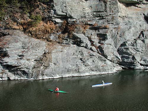
Padders enjoying a flatwater workout during winter at the Iwadatami
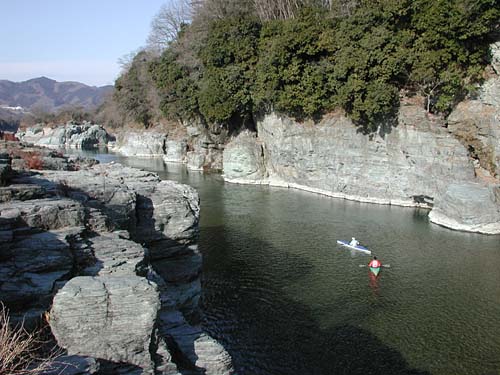
Padders enjoying a flatwater workout during winter at the Iwadatami
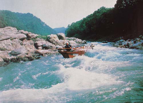
Line Kudari boats running Kotake Rapid